Cartographica Neerlandica Background for Ortelius Map No. 83
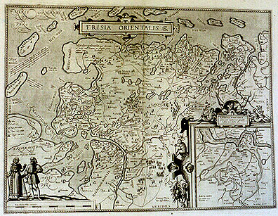
Title: FRISIA ORIENTALIS. [[Depiction] of East Frisia]. (Middle bottom:) "Joannes Floria:|nus describebat". [Depicted by Iohannes Florianus]. (Inset 163 x 170 mm:) RIDERIAE PORTIONIS | "facies, ante inundationem, qui post:|ea sinus maris factus est". (Lower left corner of inset:) "Incidit hæc inundatio | circa 1277. | Decembris 25" [Image of part of Rideria before the flood, which later occurred in this branch of the sea. This flood happened in December 25, 1277]. (bottom right corner:) "Cum priuilegio decennali." [With a privilege of ten years]. (Top left:) "Ante aliquot annos cum maiores adhuc eßent hæ duæ insulæ tam | augustum erat utriumque Amasij ostium, vt vix maioribus nauibus | non nisi peritis nautis pateret, minusque periculi erat ab Oceano. Nunc | vero insulis maris seuitia imminutis, frequentiores inundationes hæcv| Frisia experitur". [Some years ago, when these two islands were larger than they are now, the mouth of the river Ems was on both sides so narrow, that for larger ships it was not wide enough unless sailors were very experienced, but there was less danger when coming from the ocean. Nowadays, the roughness of the sea has diminished, but this Frisia now experiences inundations more frequently]. (Middle left:) "Hec turris ex continente | apparenter visa, futu: | ram breui tempestatem | minatur". [When this tower is visible from the main land, a brief storm threatens in the near future.] (Upper middle left:) Nordergebiede, "ager vberrimus, | et incolis adeo frequens, ut contiguis fere | ædibus totus | habitetur". [The North area has such exuberant fields, and is so densely inhabited, that the houses stand next to one another]. (Lower left:) "Veterum Frisorum habitus". [What the old Frisians looked like].
Plate size: 378 x 500 mm
Scale: 1 : 200,000
Identification number: Ort 83 (not in Koeman; Meurer: 135/I; not in Karrow, van der Krogt AN: 2310:31B)
Occurrence in Theatrum editions and page number:
most if not all 1592L45 (400 copies printed) (8th line from the top ends: æternã ope- ; last line, left aligned: Esens,alter Ieueren,à primarijs eorum opidis sic vocati.),
1595L47 (500 copies printed) (8th line from the top ends: æternam ope- ; last line, left aligned: Esens,alter Ieueren,à primarijs eorum opidis sic vocati.),
1598F50 (525 copies printed) (last line, left aligned: mez du nom des villes principales qui sont en ladite region.),
1598/1610/1613D39 (100 copies printed) (last line, centred like 5 lines above it, in Gothic script like the entire text: hooft-steden ghenoemt.),
1601L47 (200 copies printed) (last line, left aligned: Vbbonem Emmium.),
1602S50 (250 copies printed) (last line, left aligned but almost full width: villas principales, que assi se llaman. D'el sitio, naturaleza, y costumbres de esta Frisia lea a Vbbone Emmio.),
1602G50 (250 copies printed), (essentially the same as 1580/1589G: last line, left aligned, in Gothic script like the entire text: andere Graaffschaften/Esens nemlich/und Jeveren/die von ihren Fürnembsten Stätten also genennet seind.),
1603blank (Vri1) no text or page number,
1603L50 (300 copies printed) (25th line ends: millesimo ; last line, full width: ren,à primariis eorú opidis sic vocati. De huius Frisiæ situ,natura & moribus lege Vbbonê Emmium.),
1606E50 (300 copies printed) (last line, left aligned: of the people, read "Vbbo Emmius".),
1608/1612I55 (300 copies printed) (last line, left aligned: l'vno d'Esens,l'altro di leueren , cosi dalle loro principali terre chiamati.),
1609/1612L54 (300 copies printed) (25th line ends: qua- ; last line, full width: ren,à primariis eorû opidis sic vocati. De huius Frisiæ situ,natura & moribus lege Vbbonê Emmium.),
1609/1612/1641S53 or sometimes 55 (325 copies printed) (last line, left aligned: sus villas principales, que assise llaman. D'el sitio ,naturaleza, y costumbres de esta Frisia lea a Vbbone Emmio.).
Approximate number of copies printed: 3450.
States: 83.1 as described.
83.2: a second state occurs from 1603 (Vrients Low Countries) onwards, in which the mile scale is reduced from 5 to 4 blocks, making space for the new place names "Wedde, Boeren tange" and the region name "De Bertaing".
Cartographic sources: based on a manuscript map by Jan Bloemmaerts or Johannes Florianus (Meurer p. 146). The "Catalogus Auctorum" also mentions David Fabricius Esensis and Laurentius Michaelis ab Hogenkirchen as authors of East Frisia maps. Source of inset is unknown.
References: A.W. Lang (1985) "Kleine Kartengeschichte Frieslands zwischen Ems und Jade", Norden, p. 24-27.
For questions/comments concerning this page, please e-mail info@orteliusmaps.com.